Your Waterfront Lot Just Moved. Legally, Nobody Moved It.
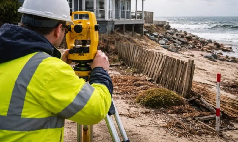
Photo: coastal property surveyor measuring shoreline erosion waterfront boundary, via altasurveymaine.com
There's a moment every waterfront surveyor knows: the homeowner standing at what they're sure is their property line, pointing at a stake, while the tide laps fifteen feet on the other side of it.
"That's not your line anymore," the surveyor says. "Honestly, it may not have been for a while."
On dry land, boundaries are boring. Iron pins, deed descriptions, a fence everyone's argued about since 1987. But where your lot meets the water, the concept of a fixed boundary starts to dissolve — sometimes literally. Erosion eats the point. Accretion builds a new point. A hurricane relocates a sandbar and, with it, somebody's riparian rights. If you're buying harbor-side property, understanding this moving-target problem isn't a legal curiosity. It's due diligence.
The Line That Won't Sit Still
Most coastal property in the United States is governed by riparian or littoral law, a body of doctrine older than most of the towns it governs. The short version: your waterfront boundary is typically defined by the water itself — the mean high-water line in tidal states, the ordinary high-water mark inland. When the water moves, the line can move with it.
Gradual change is the key word. Under the legal doctrines of erosion and accretion, slow, imperceptible shifts adjust your boundary over time. Lose ground slowly to the sea, and your lot shrinks. Watch a point build up over a decade of currents, and your lot quietly grows. Courts have generally respected this logic for two centuries because the alternative — freezing lines to a survey from 1922 — produces absurdity.
Then there's the exception that wrecks everybody's fall plans: avulsion. That's sudden, dramatic change — a hurricane scours out a new channel overnight, a storm pushes the dune line back forty feet in a weekend. In an avulsive event, the old boundary survives. The line stays where it was, even if it now runs through open water or, awkwardly, through your neighbor's new living room.
"People assume a storm automatically means they lost land," says a maritime attorney who's spent twenty years untangling coastal boundary disputes. "Sometimes a storm is the best thing that ever happened to their claim. The trick is proving which kind of change occurred — gradual or sudden — and that fight is fought with decades of aerial photos, old surveys, and tide records."
When the State Shows Up
Here's the part that surprises newcomers: in many coastal states, the state itself is a property owner in the mix. Under the public trust doctrine, the land below the mean high-water line generally belongs to the state — held for public use. So when erosion walks your shoreline back, you're not just ceding ground to the neighbor. You may be ceding it to the State of New Jersey, the Commonwealth of Virginia, or the State of Texas.
A couple on Maryland's Eastern Shore learned this the hard way. Their deed described 120 feet of sandy frontage on a tidal creek. After three nor'easters in eighteen months, the mean high-water line migrated inland — and their usable beach, measured at a spring high tide, dropped to under 80 feet. Their riparian lot didn't shrink on paper, but the deeded access to it did, and their grandfathered pier suddenly sat over state-owned bottom. "Nobody stole anything," the husband says now. "The creek just moved in."
The inverse happens too. Accreting sand has quietly expanded frontages on the Carolina and Florida coasts, and new land can come with new questions — including whether the state retains rights over the freshly built-up acreage. Florida's boundary statutes, for instance, treat accreted land differently depending on how and when it formed. Growing your lot is nice. Growing it into a legal gray zone is not.
What a Surveyor Can (and Can't) Tell You
A licensed surveyor is your first call, but go in with realistic expectations. A survey pins down where the boundary is today, based on current water levels and the best available evidence. It cannot promise where the line will be after the next wet decade.
What a good coastal survey should include:
- The datum used — mean high water? mean lower low water? These aren't interchangeable, and the difference can be tens of feet of frontage.
- Erosion rate data — many coastal counties and states publish long-term shoreline change maps. If your target shoreline has been retreating a foot a year for fifty years, that's a trend, not a fluke.
- Pier and dock rights — an existing structure over state bottomland may need a lease, not just a permit. Ask who holds it and whether it transfers.
- History of the line — comparing the new survey against the original plat tells you whether you're looking at gradual change (line moved) or avulsion (line didn't).
"The biggest mistake buyers make is treating the survey as a snapshot they can frame," one surveyor puts it. "On the water, it's more like a weather report. Very accurate for right now."
Five Questions Before You Sign
- Is the water tidal or non-tidal? The boundary rules can differ, and tidal states tend to be more aggressive about public rights below the line.
- What do the state's shoreline change maps show? Many coastal states publish them free. Look at fifty years, not five.
- Is there recorded litigation or a boundary agreement? A settled dispute with the neighbor is gold. An open one is a red flag with a water view.
- Who owns the bottomland under the dock? Get the answer in writing, from the state agency that regulates it, not from the seller.
- Has the shoreline been armored? Bulkheads and riprap don't stop boundary change — they often just relocate the erosion next door, which may be your neighbor's problem today and yours tomorrow.
Buy the Water, But Read the Land
None of this is a reason to walk away from harbor living. Millions of Americans own waterfront property happily, wake to foghorns and herons, and never think about avulsion twice. But the harbor's edge rewards the prepared. The buyers who thrive are the ones who understand that on the water, a deed is less like a fence and more like a treaty with a very patient, very powerful neighbor — the sea itself.
Get the survey. Ask about the trend line. Talk to the neighbor before you need to talk to the neighbor's lawyer. The water will move. Your job is to know, going in, roughly which way — and to make sure the paperwork can bend with it.